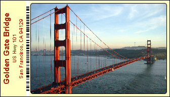
The NaviCard system is part of the Multimedia Navigation System. NaviCard is an information card that presents a location on traditional paper card with a photo and text. The NaviCard is equipped with a special printed geocode that gives the geographical location of the place shown on the NaviCard to an accuracy of 1 meter. NaviCard-compatible navigation device guides you to the location shown on the card. The card is also capable for setting your smartphone's navigation to the location shown on the card.

NaviCard – size 50 x 90 mm or 2" x 3,5"
History of NaviCard
NaviCard was created in 1994. The new medium is patented under U.S. Patent No. 5,864,125. The prototype of the navigation device for receiving the NaviCard was made in 1997. At that time, accurate position data from GPS satellites were not yet available to civilian GPS receivers. On May 1, 2000, U.S. President Bill Clinton made a decision to increase the accuracy of civilian GPS data. Subsequently, it became possible to use GPS navigation devices within the cities and any other urban enviroment. However, digital maps were only available in a few countries. Accelerating technological development has also filled this gap within a few years. The next major breakthrough was the online Google Maps in 2005. The online digital map allowed us to download the geographical coordinates of possible destinations worldwide. This has significantly expanded the range of NaviCard production. Another breakthrough came with the release of Apple’s revolutionary novelty, the iPhone. The second edition of the iPhone, the iPhone 3G, already included a GPS unit. The iPhone 3G was launched on July 11, 2008. The development of the iPhone's operating system allowed us to create the first version of the NaviCard application in 2012. More and more possibilities have opened up in the coming years, so the current version of the NaviCard app is now able to work with all possible media. This estabilished the technical conditions for the Multimedia Navigation System. Another breakthrough has been the widespread use of the smartphone as a scanner in recent years. Nowadays, it has become common practice to use your smartphone camera as a scanner. This has matured the conditions for the widespread use of the Multimedia Navigation System, including the NaviCard, worldwide.

The NaviCard app
The NaviCard app is used to enter a destination into your smartphone's navigation system, from different média sources. The source of the destination can be a digital photo stored in the photo album on your smartphone, or a photo you receive in an email. The special printed geocode, scanned by the smartphone camera, also can sets the smartphone's navigation system to the location. The printed geocode can be displayed not only on NaviCards, but also on many other media too. The medium can be a newspaper, a book, a business card, an invitation card, an entrance ticket, a checkout block, a parking ticket and much more. The media can also be other things on which the code is placed. Souvenirs such as pens, glasses, beverage bottles and on all other cylindrical and flat objects. The code can also be placed on textile wares, either by weaving or dyeing. Hotel room key label, door unlock cards and the similar things can be made suitable for navigation. Codes that appear on your computer screen or TV screen can also be used to navigate using the NaviCard app. The code appears below the images of a travel movie can show where the video pictures made. The variety of possibilities is almost limitless. And all of these options help you find your destinations quickly and easily.
The most important features of NaviCard
1 NaviCard associates an image with a place. Image recognition is very fast. It is much faster than reading and interpreting a text. "A picture is worth more than a thousand words." This is what traditional folk wisdom says. NaviCard takes advantage of this ancient recognition.
2 NaviCard bridges language barriers. One side of the NaviCard shows a photo of, for example, a tourist attraction. A tourist does not need to know the local language because they can identify the place based on the photo.
3 A unique feature of the NaviCard is that it takes you to places that cannot be defined by country, city, street, house number type. Even a particularly beautiful tree, bush and natural formation can be found in a place far from a populated area.
4 NaviCard is also a great tool for finding the venue for occasional events. Occasional events cannot be found in central databases. A concert or a wedding casual event. NaviCard is a great tool for finding similar locations.
5 A distinctive feature of NaviCard is that it can be used to make everyday life easier, both regionally and in small communities. A service provider, such as a car mechanic, can place the code on their own business card to make it easier for their customers to find their workshop.
Become a NaviCard user to be one of the first to enjoy the benefits of the system. Download the NaviCard app for your iPhone!
